
Circular hiking routes, generated for you
Pick a start point, set a distance and how much you want to climb — Scórtol designs loop hikes across the Alps that bring you back to where you started, with an elevation profile and a GPX track to take on the trail.
Free · no account · GPX export · IT · AT · CH · SI · FR
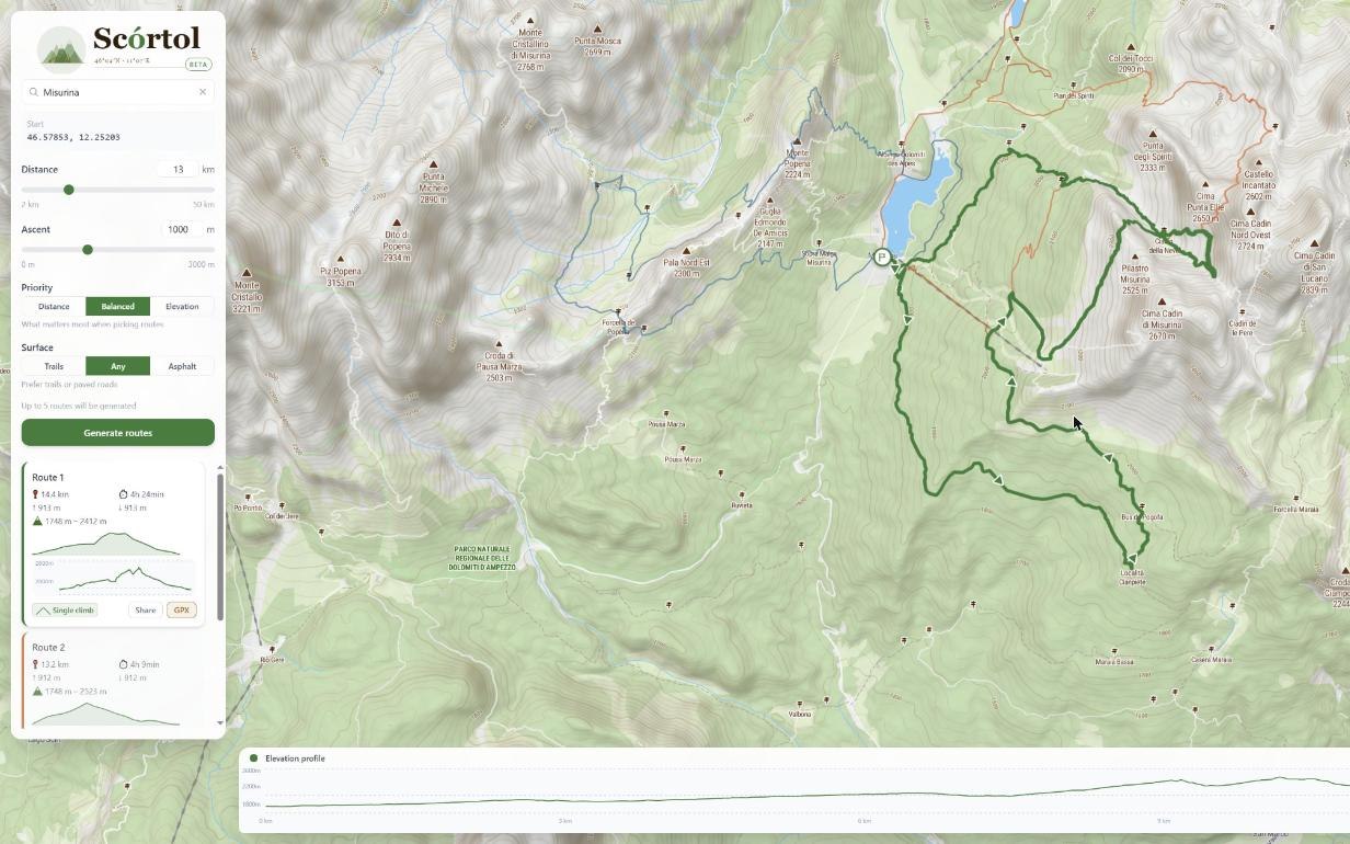
From a point on the map to a route in seconds
Scórtol is a free web app that designs circular (loop) hiking routes for you: you pick a start point, set how far you want to walk and how much you want to climb, and it returns several ready-made loops that come back to where you started — each with an elevation profile and a downloadable GPX track.
- 1
Pick a start point
Tap anywhere on the map inside the covered area, or search for a place by name — a mountain hut, a lake, a trailhead, a village. That point is where your loop begins and ends.
- 2
Set distance and ascent
Choose a target distance (2–50 km) and a target elevation gain (0–3000 m). Together they decide whether you get a gentle valley stroll or a demanding climb.
- 3
Choose priority and surface
Tell Scórtol what matters most — hitting the distance, the ascent, or a balance — and whether you prefer trails or paved roads. It biases the search accordingly.
- 4
Generate and compare
Scórtol returns up to five distinct loops. Each shows its real distance, total ascent and an elevation profile, so you can compare them at a glance and pick the one you like.
- 5
Export the GPX
Download the route as a GPX file and load it into your GPS watch, phone app or navigation device for the trail.
What makes the routes good
Scórtol is built on OpenStreetMap trail data enriched with real elevation. It genuinely walks the trail network to build loops that return to the start, prefers real paths over roads, tries to reach nearby summits and viewpoints where the ascent budget allows, and offers routes that differ from one another so you have a real choice rather than five variations of the same track.
Built for the Alps
Coverage spans the Alpine arc across five countries — from the Dolomites and the Brenta to the Mont Blanc massif, the Bernina Range and the Julian Alps.
See regions & coverage- Italy
- Austria
- Switzerland
- Slovenia
- France
Common questions
What is Scórtol?
A free online generator of circular hiking routes. Instead of drawing a track by hand, you set a start point, a distance and an amount of climbing, and Scórtol proposes several loops that return to your start.
Is it free?
Yes. Scórtol is free to use, with no account required and no ads.
What areas are covered?
The Alps across Italy, Austria, Switzerland, Slovenia and France. The covered area is highlighted on the map; see the Regions page for the main massifs within reach.
Are the routes circular?
Yes — every route is a loop that starts and finishes at the same point, so you can leave from and return to the same car park, hut or station.
Can I control distance and elevation gain?
Yes. You set a target distance (2–50 km) and a target ascent (0–3000 m), and choose whether distance, ascent or a balance of both is the priority.
Ready for your next loop?
Drop a start point on the map and let Scórtol do the planning.
Open the map